Monday, June 06, 2011

Madison's reality distortion field, or how to do a farmers' market

I was Madison, Wisconsin for the annual Congress for the New UrbanismNot coincidentally, there is a connection between Buffalo and Madison: the CNU will be in Buffalo in 2014, and my coverage affords an opportunity to examine this event and the issues as they apply to the Buffalo area. I'll also be looking at what we in Buffalo can learn from the City of Madison, regarded as one of the most progressive American cities when it comes to urban planning—and the great quality of life that has resulted.


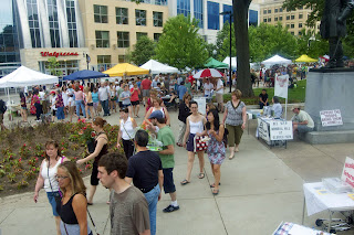
Capitol Square in Madison, WI, during the Dane County Farmers' Market, the largest event of its kind in the country.
Madison, Wisconsin is an incredible place. I mean that in both the literal and figurative senses of the word. The city has tangibly more vitality than say, Denver, at about one-sixth the size.
That's the thing that immediately struck me—how few people it takes to create a vibrant, energetic city. At least in this country, that is. Madison is in complete defiance of the way that the vast majority of U.S. cities and towns have developed, with their ubiquitously dead downtowns and placeless, mind-numbing, soul-sucking, vitality-sapping, automobile-based sprawl. In this sense, the city has much more in common with Europe than North America.
You've got to be good to be lucky

The central market square of Poznań, Poland, typical of European plazas. There is virtually no greenspace, yet this is among the most beautiful—and popular—types of public space. Framed and defined by the surrounding buildings, the space is furnished with high-quality pavements, a fountain, and several monuments. (Image from wikitravel.org)
Madison got lucky, however. It's both a college town and a state capital. The 40,000 or so students at the University of Wisconsin virtually guarantee a lively pulse of street life and nightlife. There are thousands of well-paid middle-class jobs, from university faculty and staff to the jobs in state politics, government agencies, and museums. Many world-class cultural institutions are the inevitable product of both the university and the omnipresent state government. All of these things add value to the city, attracting talent and investment in a virtuous cycle.
On top of that, Madison was never an industrial city, so it never really suffered deindustrialization, and never contained the over-concentration of noxious industrial activities that, over time, helped to devalue cities like Buffalo. Madison also never truly experienced the race and poverty problems attendant on larger industrial cities, which helped to drive out the middle class in the decades following World War II.
It's tough to screw up that equation. Not that some cities haven't. Around here, building the North Campus of UB in Amherst immediately comes to mind. But Madison made some very wise choices over the last few decades that have helped turn it into one of the hippest and most valuable mid-sized cities in the country.
The cold-weather straw man
Before discussing this further, a perniciously popular myth about weather must be debunked. Madison's success has absolutely nothing to do with its climate. The brutal Wisconsin winters are longer and more extreme than in Western New York, with nearly as much snow. Summers are hotter and more humid.
Obviously, Madison's luck doesn't include its weather, but the city's success certainly doesn't seem in any way impeded by it. Yet in Buffalo we spend a lot of time carping about our weather when it's hardly different from Madison, Chicago, Minneapolis, Boston, or Toronto, or everywhere else in the Northeast and Midwest, and in many cases much better.
This pathetic bellyaching is not just demonstrably wrong, it's disempowering. It perpetuates an ignorant stereotype among ourselves and outsiders. It's lazy. It's fatalistic. It absolves anyone of any responsibility or ability to do anything. It robs us and future generations of hope. It's a non-issue and we simply need to get over it.
There it is. Weather myth debunked. Now can we move on?
The public realm: design and behavior are the same thing
So, finally, here is the disclaimer: Madison is a reality distortion field. Yes, the conditions that undergird much of that city's success can't be duplicated in most other places. However, that success wasn't divinely ordained, either. Their reality is simply the cumulative product of the choices and sustained efforts of Madison's leaders and citizens. They've intentionally created a city for people, not cars. This is clearly reflected in the design of their streets and public spaces, which is the focus of this piece—and why Madison was an obvious choice of venue for the CNU.
In the United States, public space mostly comes in the form of the street, and sometimes the square or park. These spaces are often referred to by planners as the "public realm," which can be thought of as all of the spaces owned collectively by the public, freely accessible to everyone.
Once upon a time, American cities did a fine job designing public space. Market plazas such as those pictured here were often not as ornate or refined as European plazas, but they were designed using the same principles. The top image is Market Square in Portsmouth, NH, 1853 (wikipedia.org). The bottom image is the Chippewa Market, Buffalo, 1896 (buffaloha.com).
Public space can be designed for different purposes. If one wants social, public activities like an outdoor market, a memorial service, or some other such event, one needs a specific type of space for that to take place. But in recent decades, almost all older cities and towns either mangled or entirely removed most of their good public spaces, usually in the effort to accommodate the automobile. As a result, we've lost much of the knowledge, and even the language, of good urban planning: witness the misnomic appropriation of words like "plaza" or "square" in the branding of suburban strip shopping centers.
Speaking of which, one of the primary goals of the CNU is to reclaim the language and revive the knowledge of civic art and placemaking. In terms of the design of public or civic space, the concepts of square, plaza, and park are a very good place to start.
Before World War II, American towns and cities did a pretty darn good job of creating all types of civic space, including market plazas. Here in Buffalo, over the last 60 years or so, the city removed four or five outdoor marketplaces that were distributed throughout various neighborhoods. Like almost every other American city, many were converted into parking lots. Others were demolished, often along with their surrounding neighborhoods, in the name of "urban renewal." Yet others were simply put out of business by the new economics of sprawl and the supermarket.
Meanwhile, the vast majority of the suburbs were designed around the car from the very start, and have never had any of these types of civic space. Even the most basic and normal civic activities, such as parades or fairs, don't work very well in a strip mall parking lot or on a traffic-clogged suburban arterial. You can't have a civic life if you don't have good civic spaces. This is a big part of the reason why suburbs are often described as isolating and socially disconnected, even by some of their staunchest advocates. And, because of their car-centric design, low population density, and segregated-use zoning, most post-WWII ’burbs will probably never be able to build and sustain successful public spaces other than large, drive-in parks and sports complexes.
In any case, the design of parks and other types of civic space is much more sophisticated than just plopping down some trees or baseball fields. Urbanistically, there are three basic types of civic space: the square, the plaza, and the park. These fundamental types are designed to meet the three basic needs of a community: the civic, the economic, and the recreational. Properly designed, all types of public space also serve the fundamental social needs of people. Meeting these needs is essential for healthy, thriving civic life. For the purposes of this discussion, here are short definitions of the three types:
  • The square (known otherwise as a town square, neighborhood square, or village green, depending on context), usually fronted by civic buildings like the town hall, is designed for civic functions like parades, speeches, and demonstrations. The center of a square is the natural (and intentional) place for civic monuments, or in the case of Madison, the entire Capitol building, whose dome creates a beautiful vista for the eight streets radiating outward from the square.
  • The plaza (sometimes called a market plaza or market square) is intended for economic activities such as public markets, fairs, and festivals. The design of a plaza has some interesting caveats: most activities associated with a plaza have high foot-traffic, and vendor vehicles must also have access to the site. These activities are tough on grass surfaces, so plazas typically contain little or no greenspace. This runs counter to most Americans' intuition; market plazas have been absent from our culture for several generations. However, all that hardscape doesn't make plazas any less attractive than squares or parks; some of the most beautiful public spaces ever created are found in the lovely market squares of Europe.
  • The park (and the smaller playground) is designed for differing types of passive and active recreation and other social activities. A note on parks: in Buffalo and throughout the U.S., we're quite familiar with large, sprawling parks of the type that Frederick Law Olmsted designed. Indeed, Olmsted designed Buffalo's park and parkway system, the first such system in the nation, and the first of many more commissions throughout the U.S. Olmsted had more influence than any other figure in American landscape design, and his principles shape how we as a culture think about the role of parks and public space. The Olmstedian park is typically a large, spawling simulation of the natural landscape, intended to be an escape from hectic urban life. This is all well and good, but because Olmsted's ideas have become so pervasive, American cities and towns tend to lack the smaller, more formal, more accessible types of local parks that are integral to functional, beautiful neighborhoods.
Another subtlety that may surprise many Americans is that there aren't always strong distinctions between these types. Indeed, most civic space is hybrid to some extent, and there are many fine examples of civic spaces intentionally designed to serve double- or triple-duty. These hybrid spaces are often more successful than single-use spaces because they support a variety of simultaneous activities, or have varying activities at different times of day, or on different days of the week—as Madison's Capitol Square attests.
How to do a farmers' market
Madison's Capitol Square is a well-designed public space, with buildings that front the sidewalk and define the space of the square, with formal parkland inside the square. There is just enough hardscape so that the space can do double-duty as a marketplace or festival; the square doesn't turn into a mud pit during an outdoor market. In comparison, Buffalo's excellent Elmwood-Bidwell Farmers' Market unfortunately takes place in a public space never designed for such a high-traffic function, resulting in problems like mud and dead grass on Bidwell Parkway.
Let's take the specific example of the Dane County Farmers' Market. On Saturdays during the spring, summer, and fall, the market is arrayed around Madison's Capitol Square.
This is not a coincidence. Capitol Square is the natural location for this kind of event; it's the physical and psychological center of the city and region. It is a beautiful public space, with the Wisconsin Capitol building at the center of a large, tree-lined square, and dignified downtown buildings containing shops, restaurants, and offices framing the edges.
Of course, this design is also no accident. Most great places are the product of intention. Like public squares in most older American cities, the space of Capitol Square was planned and designed precisely for both daily life and for special civic events like a public market. Many types of activities, from the mundane to the ceremonial, reinforce each other and activate the sidewalk. In addition to people on foot and bicycle, cars circulate around the square. But the outer roadway is relatively narrow, so cars move efficiently but slowly. They don't threaten the safety or peace of people using the public space.
The whole effect is one of civility, vitality, and fun. From the very center of town, Madison is a city that cares about people. And people respond by using the streets and squares. There are shoppers, loungers, street performers, and people just passing through. Even on a day-to-day basis, there is more vitality here than in American cities many times the size. It's a refreshing, ennobling experience.
The whole kit of parts

Vitality increases exponentially when several activities are combined in one space. Madison's farmers' market also includes many other synergistic activities, including live music, a car show, and daily activities such as shopping and dining, connecting seamlessly to the always vibrant strip of State Street.
From a design perspective, the basic tools of planning employed to make a healthy public realm come from a sort-of "kit of parts." While there is a lot of flexibility regarding design, certain basics are mandatory. In order to be successful, you need the whole basic kit of parts, which includes the following:

  • Sense of enclosure. A successful space that is defined emphatically by buildings and/or trees. A public space must have a sense of enclosure; it must feel like an "outdoor room." Orderly rows of trees and buildings that line up along the sidewalk do the trick.
  • More space for people, less for cars. There must be a significant amount of space devoted to the pedestrian: wide sidewalks and, in case of a square, generous areas of orderly hardscape and greenscape. Roads and travel lanes should be narrowed to provide safe, efficient traffic flow.
  • Permeable ground floor. In the case of squares or retail streets, buildings must contain a mix of uses, not just office space or some other single use, with a "permeable" ground floor fronting the sidewalk, containing shops, restaurants, and cafés.


  • Connected and walkable. The space must be physically connected and in close proximity to the rest of the city or town, easily accessible by various modes of transport, but most importantly within walking distance of neighborhoods.
Here in Buffalo, the weekly Elmwood-Bidwell Farmers' Market is a very successful event, and has been a wonderful, natural addition to its neighborhood. Like so many other such markets across the nation, the Elmwood-Bidwell Market has become not just a forum for local agriculture, but for local culture as well. The market not only fulfills its basic economic function, but is also a place to socialize, to engage in those daily communal acts that create an authentic community.
Unfortunately, Buffalo's Elmwood Village never really had a market square, so the only logical place to put it was at the only true civic space in the neighborhood: the intersection of Elmwood Avenue and Bidwell Parkway. In the future, the community might do well to consider creating a proper plaza. If this happens, it probably won't be at its current location, where there are strict protections for the historic Olmsted-designed parkway. Luckily though, there are a few parking lots and other empty parcels along Elmwood that could be converted into a beautiful, functional market plaza. It would be wise to identify and reserve one or two of these sites before they are privately developed. As local agriculture makes its way back into all of our lives, this would provide a much-needed type of public space, adding even more value to an already vibrant neighborhood.
Buffalo's Niagara Square was once a lively public space, accommodating a healthy balance of pedestrians, trolleys, and cars. Removal of streetcar tracks, widening of the roadway, and elimination of interior on-street parking have created a comparatively desolate environment dominated by high-speed automobile traffic. The top image is Niagara Square in 1913 (buffalonian.com); bottom is Niagara Square in 2011 (gsa.gov).
A final note on one of Buffalo's most important, visible, and abused public spaces: Niagara Square. The square is the center of Joseph Ellicott's radial street plan for Buffalo, and the proverbial heart of the region—much like Madison's Capitol Square.
Over the years, however, Niagara Square has become less and less people-friendly, as intrusive alterations were made in the attempt to accommodate the automobile. The roadway is far too wide, and fast-moving cars are a dominating, threatening presence. The square feels inaccessible and disconnected from the surrounding city.
Serving as Buffalo's civic "front yard," Niagara Square should be one of the city's most beautiful and welcoming public spaces. The list of design problems might be long, but it's a pretty easy prescription to start civilizing the square: narrow the roadway, widen the sidewalks, add pedestrian islands and well-marked crosswalks, add curbside parking (or even angled parking), change the asphalt to brick, add rows of trees (and use proper species of tree), and replace the highway-style "cobra" lights with lanterns.
That's a tall order, but the good news is that the work can be done incrementally, and any one of those changes will make the place noticeably better, adding real value.
The value of public space
Speaking of value, perhaps the best test of the design of public space is how many people naturally go there even when a festival or other special event isn't going on. Great public spaces are great not just due to practical utility, but because people enjoy just being there. They're beautiful. They're spiritually rewarding. And because they are a physical part of the daily lives of citizens, great public spaces help to give a neighborhood that intangible but palpable "sense of place." Going to the grocery, post office, or pharmacy may be a mundane chore, but a properly assembled public realm can dignify the trip, and help connect you physically and psychologically to your community.
Well-designed public spaces raise the value of the whole neighborhood, and in aggregate, the whole city—including everyone's property values. These days, that's a message most Americans would love to hear.

Tuesday, May 31, 2011

A tale of two cities: the sidewalk perspective

I'm in Madison, Wisconsin this week for the annual Congress for the New Urbanism. I'll be posting dispatches here, at Artvoice, and at Buffalo Rising.

Not coincidentally, there is a connection between Buffalo and Madison: the CNU will be in Buffalo in 2014, and my coverage this week affords an opportunity to examine this event and the issues as they apply to the Buffalo area. I'll also be looking at what we in Buffalo can learn from the City of Madison, regarded as one of the most progressive cities when it comes to urban planning—and the great quality-of-life that has resulted.


Let's start with a specific issue: street design. The Congress doesn't officially start until tomorrow, so I've used today to get to know a bit of downtown Madison and critique the design of the streets and public spaces. This didn't stop me from trolling the online pages of The Buffalo News; during a break this afternoon I spied an article today about sidewalks and pedestrian safety. Author Bruce Andriatch merely scratches the surface of this important issue, falling short of addressing it properly.

But who's to blame him? A design subtlety that is lost on most non-planners, including Buffalo News columnists, is that sidewalks are a necessary element for safe street design, but insufficient in themselves. If pedestrians are being endangered, the design speed of the road is usually the culprit. Many if not most roads in this country are intentionally designed for much higher speeds than the posted limit. A 30 mph speed-limit sign on a road designed for 50 or 60 mph is a futile—and sometimes fatal—exercise in wishful thinking.

Pedestrian Injury Frequency and Severity Based on Vehicle Speed (Source: National Highway Traffic Safety Administration, image from the Bicycle Alliance of Washington)

Here are the sobering facts: at 30 mph, vehicle-pedestrian accidents are fatal in about 5% of cases; at 40 mph, fatalities are 90%. This is not to mention injuries, which can be devastating in their own right: incapacitating injuries are significantly less likely and less severe at slower speeds.

Therefore, the actual, effective solution involves "traffic-calming" the roadway so that drivers naturally move at slower, safer speeds. There are many methods to accomplish this, used in various combinations according to the specific situation. These include: fewer and/or narrower lanes, planting orderly rows of roadside trees, allowing curbside parking, using brick or other types of pavers for the road surface, curb bulb-outs, employing roundabouts instead of signalized intersections, smaller corner radii, etc.

State Street in Madison, WI employs virtually all of the basic traffic-calming devices, including a narrow roadway, wide sidewalks, and orderly rows of curbside trees. This results in a street that easily accommodates all modes of transportation while being a pedestrian destination—it's simply a pleasant place to be.

Done properly, traffic throughput is still maintained, with less stop-and-go frustration for drivers, and much greater safety and civility for all users of the roadway, including pedestrians and bicyclists. For the vast majority of surface roads, there is simply no reason to design for a speed limit over 30 mph. Doing so seems careless and downright irresponsible, but this is the unfortunate norm for most highway departments.

This isn't to say that traffic engineers are malicious—they're just following a prescribed set of rules. The engineering standards that govern most roadway design were written in the mid-20th century, in the midst of a obsession with the automobile and the high-speed expressway. Higher design speeds were considered safer for cars and drivers. This myopic goal ignored any other users, as well as the physical context of the road itself. That the road might be part of a town or city neighborhood hardly entered into the equation. Under these standards, still in effect today, roads are too-often treated identically to expressways, designed only for the high-speed convenience and safety of cars. What happens beyond the curb or shoulder doesn't matter.

Buffalo's Elmwood Avenue, the urbanistic equivalent of Madison's State Street, employs many of the same traffic-calming methods, but sidewalks are often too narrow, driving lanes too wide, and street trees are often missing or poorly maintained.

The good news is that the rules are changing. The old standards, embodied mainly by the AASHTO highway design manuals, have been superseded by new tools and standards, most recently (and importantly) the ITE design manual Designing Walkable Urban Thoroughfares: A Context Sensitive Approach, adopted in 2010. Traffic engineers and citizens alike now have a sophisticated set of official standards with which to design roads that serve all users and all contexts.

Incidentally, on May 24, Transportation for America released a comprehensive report on pedestrian deaths. Dangerous by Design studies 47,000 pedestrian fatalities in the US from 2000-2009, mapping them on an interactive web page. Enter any location, and find out details on fatalities, thoroughfare type, etc. Check out pedestrian fatalities in your neighborhood; you may learn something about street design and safety in the place you live.